Thursday, December 5, 2013

Winter Storm Beginning

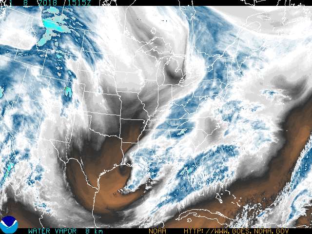
We're under a Winter Storm WARNING this evening through Friday, expecting a quarter inch to a half inch of ice, and snowfall, varying greatly depending on your  location.  Freezing rain, in fact, is moving through faster than forcast yesterday as the system has sped up.

Temperatures are dropping and we're seeing a changeover from rain to sleet and freezing rain  already this morning in Southern Illinois and SEMO.  

Snowfall projections, right now, should be around 4-5 inches right along the Ohio River, and then less for most of the region southeast of the Ohio River.  North of the Ohio could see more, perhaps 6 plus inches.  It won't be melting anytime soon as temperatures continue falling today and Friday, bottoming out with lows in the low teens Friday night, and highs Saturday only in the 20s.

Ice accumulations still look like they will be in the 1/4" to 1/2" range for most of the region south of the Ohio.  In fact the most troublesome looking part of our area right now is east of a line from Fulton to Princeton, KY wihch could see ice totals higher than a half inch.  That could cause some  power outages and trees to come down.  Even so, his storm WILL NOT be as severe as the Ice Storm of 2009.  In the 2009 ice storm, we had a swath of ice accumulation in the 1.5" to 2" range.  That gives you an idea of just how bad 2009 was!

This round of winter precipitation should end Friday night before another round of winter mix comes in Saturday night through Monday, but right now it doesn't look as significant as this first round.


Latest Paducah, Kentucky, weather conditions and forecast


CURRENT CONDITIONS:
Kentucky   Tennessee    

Illinois        Missouri
Facebook   Twitter


RADAR:

SATELLITE:


FORECASTS:

Severe WX Outlook:


Storm Shield Tornado Shelters (Click Here)

 Thunderstorm Outlooks: 


Hydrology:


Rainfall Forecasts:


Wednesday, December 4, 2013

SO How Much Snow?

There's a wide swing on ow much snow we'll get Friday!  So far there seems to be pretty good agreement we're looking at 0.25 to 0.50" of ice from sleet and freezing rain, but how much snow?

Well....I saw at least one local outlet, using the RPM model, predicting near 14" of snow for Paducah down to more than 4 inches for the KenTenn.

On the other hand, the NWS suggesting only a 10% chance of 4 inches of more for Paducah.
The latest run of the GFS suggesting 2 inches or less.
While the NAM computer model suggesting 4 inches of less.

What's going to happen? How much? Where? We'll see!  THIS is one of the things which makes it such a difficult call for meteorologist!

Tuesday, December 3, 2013

UPDATED: Winter Storm Thursday-Friday

There's a Winter Storm Warning in effect from Thursday Night from Friday afternoon! Wintry precip could affect travel beginning Thursday evening and  through Friday and if enough ice accumulates, there could be some power outtages!

Already, the "Raise The Roof" concert to benefit the Brookport Tornado Victims, scheduled for Harrahs Metropolis Thursday Night, has been canceled due to the impending storm.  Also, the Metropolis Christmas parade has been canceled.

Here's what we're seeing now.  It looks like we could see a changeover from rain to sleet and freezing rain Thursday afternoon or evening and then on Friday, mixed with snow. Snowfall projections, right now, should be around 2 inches or so for most of the region south of the Ohio River.  North of the Ohio could see more, perhaps 4-6  plus inches.

Right now it looks like we're a cinch to see at least some ice accumulations, possibly close to 1/2"  by Friday afternoon in a few locations.  This would be enough to cause some power outtages, but not widespread, long term outages.  Everything hinges on how quickly or slowly the temperature drops Thursday night into Friday morning.

If everything goes according to the latest models, travel Thursday night and Friday could be impacted.  It all depends on when the surface freezes! We'll continue to monitor the latest forecast data. This storm WILL NOT be as severe as the Ice Storm of 2009.  In the 2009 ice storm, we had a swath of ice accumulation in the 1.5" to 2" range.  That gives you an idea of just how bad 2009 was!

Remember, problems with ice accumulation usually begin with just a small amount, which impacts travel.  With 1/4 to 1/2" inch of ice, we start to see some  power lines and trees affected, and with more than 1/2", we see MAJOR impacts.  Let's hope our impacts are on the minimal side, but we'll be watching and updating.

At any rate, the precipitation should end by Friday night and temps will be very cold through the weekend, and....uh....ANOTHER wintry mix round could affect us Saturday night into Sunday.  This one should being another round of snow, sleet and freezing rain, although warming temperatures Sunday could lessen the additional damage.  Fingers crossed!


From the NWS Paducah: Forecast Ice Accumulations through Friday:

NWS Forecast Snow Accumulations through Friday:


Latest Paducah, Kentucky, weather conditions and forecast


CURRENT CONDITIONS:
Kentucky   Tennessee    

Illinois        Missouri
Facebook   Twitter


RADAR:

SATELLITE:


FORECASTS:

Severe WX Outlook:


Storm Shield Tornado Shelters (Click Here)

 Thunderstorm Outlooks: 


Hydrology:


Rainfall Forecasts:


Monday, December 2, 2013

Possible Ice Accumulations Thursday Night-Friday Morning

We're still watching for a possible wintry mix, Especially Thursday night into Friday, but our attention is turning more to possible problems with ICE than snow.  Snowfall accumulations at this point, although we're still a ways off, appear to be around only 2 inches. This could change and shift A LOT between now and then!

Ice accumulations, from freezing rain, however appear to be more troublesome.  Right now it looks like we're a cinch to see at least some ice accumulations.  The Southern part of our region, in NW Tennessee, could see more ice than in Western Kentucky, Southern Illinois and SE Missouri.  It looks like even more ice could accumulate in Northern Arkansas and westward.  We should know more within 24 hours, but we are monitoring this VERY closely.

If everything goes according to the latest models, Friday morning's commute could be severely impacted.  We'll continue to monitor the latest forecast data. At this time, however, for us, it does NOT appear to be as severe as the Ice Storm of 2009, BUT we're watching.

Remember, problems with ice accumulation usually begin with just a small amount, which impacts travel.  With 1/4 to 1/2" inch of ice, we start to see power lines and trees affected, and with more than 1/2", we see MAJOR impacts.  Let's hope our impacts are on the minimal side, but we'll be watching and updating.


This depicts ice accumulations of 1/4" and higher through Midnight, Thursday night.  We expect more possible freezing rain the rest of Thursday night and into Friday.


Here's a look at a couple of different models for snow: Note this first model goes out 120 hours into the future, while the second only goes out 96 hours.


Latest Paducah, Kentucky, weather conditions and forecast


CURRENT CONDITIONS:
Kentucky   Tennessee    

Illinois        Missouri
Facebook   Twitter


RADAR:

SATELLITE:


FORECASTS:

Severe WX Outlook:


Storm Shield Tornado Shelters (Click Here)

 Thunderstorm Outlooks: 


Hydrology:


Rainfall Forecasts:


Sunday, December 1, 2013

Chances For Wintry Mix And Snow Later This Week!

We're watching for a chance of wintry mix of weather later this week, as a cold front and low pressure system push through the area and sag southward.  Right now, it even appears we could see some accumulating snow Thursday night into Friday but it's a little to say how much! Until then, we'll see temperatures above average with a couple of changes for light rain or fog.


Here's a look at a couple of different models, note this first model goes out 120 hours into the future, while the second only goes out 96 hours.


Latest Paducah, Kentucky, weather conditions and forecast


CURRENT CONDITIONS:
Kentucky   Tennessee    

Illinois        Missouri
Facebook   Twitter


RADAR:

SATELLITE:


FORECASTS:

Severe WX Outlook:


Storm Shield Tornado Shelters (Click Here)

 Thunderstorm Outlooks: 


Hydrology:


Rainfall Forecasts: