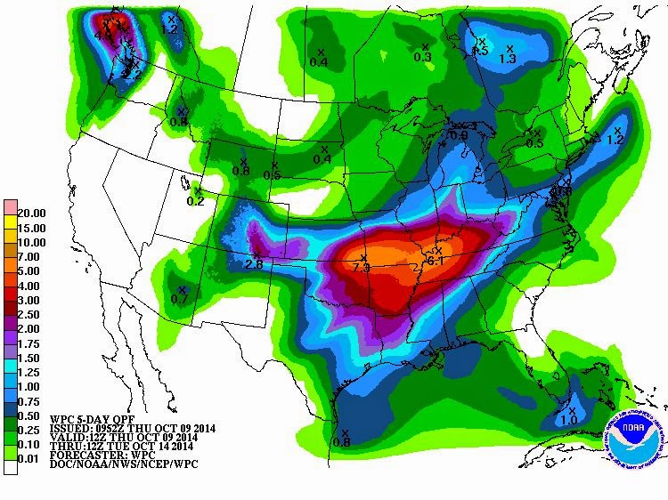
Sunday, October 12, 2014

Chances For Severe Storms Today and Tonight

We'll have a chance of Severe Storms today and tonight as a cold front approaches, then moves through the area!  The biggest threats will be large hail and damaging winds with come possible tornadoes.  A squall line is expected to form and move through the region this afternoon into tonight which could include some high winds (up to 75 mph) and possible embedded tornadoes (perhaps STRONG tornadoes).  Ahead of this, we could see some individual storms reach severe levels.  Along the way, we're still expecting additional rains!

 Your can hear my forecasts each weekday on Newstalk 94.7, 95.5, 570AM and 1320AM, along with The Mix 94.7 and Willie 102.1.  Remember, when the power's out, you can still hear our forecasts and live reports on these stations, too.


CURRENT CONDITIONS: 
 Kentucky   Tennessee      
Illinois        Missouri
Facebook   Twitter


RADAR:
Paducah   Memphis    
St Louis Ft Campbell     

SATELLITE:
Regional VIS   IFR      
Water Vapor   Menu


FORECASTS:

Hydrology:


Thursday, October 9, 2014

HEAVY Rainfall Possible Next Few Days!

HEAVY RAINFALL is a big concern between now and the end of this rainy pattern.  That won't be until Tuesday.  EVERY DAY and NIGHT we'll have a good chance of showers and thunderstorms until then, with a chance of upwards of 6 inches of rainfall total during these next few days.  There will also be a chance for strong storms Monday (Columbus Day) and Monday night but still a ways off from then.  In the meantime, prepare for lot's of water!


 Your can hear my forecasts each weekday on Newstalk 94.7, 95.5, 570AM and 1320AM, along with The Mix 94.7 and Willie 102.1.  Remember, when the power's out, you can still hear our forecasts and live reports on these stations, too.


CURRENT CONDITIONS: 
 Kentucky   Tennessee      
Illinois        Missouri
Facebook   Twitter


RADAR:
Paducah   Memphis    
St Louis Ft Campbell     

SATELLITE:
Regional VIS   IFR      
Water Vapor   Menu


FORECASTS:

Hydrology:


Monday, October 6, 2014

Strong to Severe Storms Possible Tonight. WET Week Ahead

We'll have an increased chance for showers and thunderstorms through Tuesday, with a chance for strong to severe storms this afternoon and tonight as a cold front pushes through the region.  The biggest threats are large hail and high winds although an isolated tornado cannot be ruled out.

We'' have a good shot at showers and storms each day over the next week, with the possible exception of Wednesday, and we could see some HEAVY rainfall amounts over the next 7 days: Perhaps as much as MORE than FOUR INCHES.


 Your can hear my forecasts each weekday on Newstalk 94.7, 95.5, 570AM and 1320AM, along with The Mix 94.7 and Willie 102.1.  Remember, when the power's out, you can still hear our forecasts and live reports on these stations, too.


CURRENT CONDITIONS: 
 Kentucky   Tennessee      
Illinois        Missouri
Facebook   Twitter


RADAR:
Paducah   Memphis    
St Louis Ft Campbell     

SATELLITE:
Regional VIS   IFR      
Water Vapor   Menu


FORECASTS:

Hydrology: